
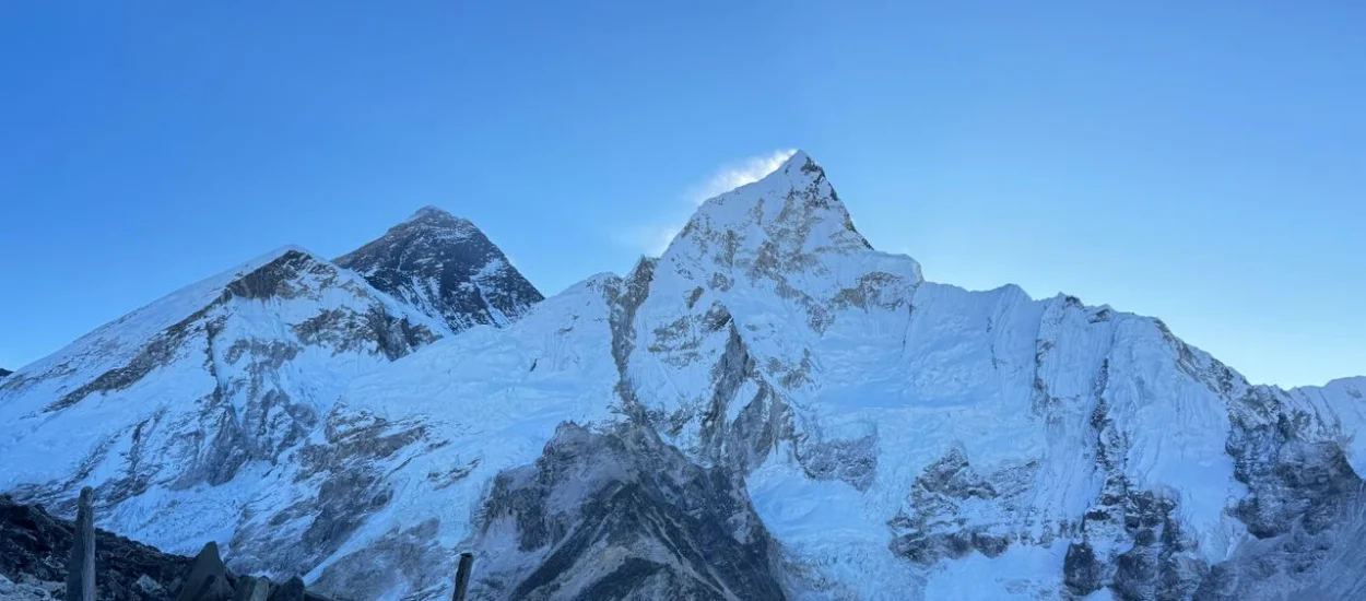
The high point of the Short Everest Base Camp Trek is Kala Patthar, sitting at 5,545 meters. Across 9 days of walking, trekkers cover close to 130 kilometers through the Khumbu Valley on the way to Base Camp and back down. Those figures tell you what kind of trip this actually is: not an extreme mountaineering expedition, not a gentle countryside walk, but a genuinely demanding high-altitude journey compressed into a shorter window.
Spanning 12 days total, this itinerary tracks the standard Everest Base Camp trail through Namche Bazaar and Tengboche without deviating onto side trails or alternate high routes. The highest overnight stop is Gorak Shep at 5,164 meters, while Kala Patthar itself is typically climbed in the early morning, when the sky is usually clearest and conditions most settled. Daily walking stretches range from 5 to 7 hours, with the Base Camp and Kala Patthar day pushing closer to 7 or 8 hours of movement.
Because the schedule only builds in one dedicated acclimatization stop, at Namche Bazaar, there’s little buffer for setbacks or a slower-than-expected pace. Rest, fluids, and a measured walking rhythm aren’t optional extras here; they’re central to finishing safely. Since the route goes out and returns along the same trail, the descent naturally helps the body recover as oxygen levels rise again.
Lodging throughout the trek is in standard Khumbu teahouses, with all trekking meals included. Before and after the mountain stage, nights in Kathmandu are spent in comfortable 3-star hotels.
The trek operates chiefly during Nepal’s spring and autumn windows, when visibility, trail conditions, and Lukla flight reliability are at their strongest. Above all, this itinerary favors trekkers who value steady, disciplined progress over rushing toward the finish line.
This shortened Everest Base Camp itinerary is built for trekkers with some hiking background already under their belt, not absolute beginners. The reasoning is straightforward: with only one acclimatization day scheduled at Namche, there’s limited room for the body to gradually adjust to thinning air.
It suits people who’ve already handled multi-day hikes and understand how to manage physical fatigue over consecutive days.
| Requirement | What It Means in Practice |
| Trekking background | Prior experience with multi-day treks or hikes |
| Daily stamina | Able to walk comfortably for 5–7 hours, repeated over many days |
| Baseline fitness | Consistent physical activity leading up to the trip |
| Mental approach | Willingness to move slowly and respect altitude guidelines |
BMI alone won’t determine whether you succeed, but it does offer a rough sense of the physical load you’ll carry at altitude.
| BMI Range | General Expectation |
| 18.5–25 | Typically well-positioned if reasonably active |
| 25–30 | Achievable with solid fitness and trekking experience |
| Above 30 | Greater physical strain and slower recovery at altitude |
That said, an active person with a higher BMI frequently outperforms a sedentary person with a lower one. Training and conditioning matter more than weight on its own.
This itinerary isn’t the right fit for complete beginners, particularly those lacking long-distance hiking experience. It’s also not advisable for anyone with a history of serious altitude sickness, poorly controlled asthma, cardiac issues, high blood pressure, or unmanaged diabetes. Trekkers in these categories are generally better served by the classic Everest Base Camp Trek, which allows more days for the body to acclimatize.
In short, this route rewards trekkers who prepare thoroughly and understand that altitude responds to patience far better than to speed.

This journey takes travelers from Kathmandu’s 1,400 meters up to Kala Patthar’s 5,545 meters in under two weeks. That pace of ascent is the biggest safety variable on the whole route. Past 3,000 meters, the body can’t fully adjust in a single night, and past 4,000 meters, minor errors in judgment can escalate quickly. Left unmanaged, altitude sickness can derail an otherwise well-planned trip.
| Trail Location | Elevation (m) | Why It Matters |
| Lukla | 2,860 | Sharp elevation gain right after leaving Kathmandu |
| Namche Bazaar | 3,440 | The trek’s only built-in acclimatization stop |
| Tengboche | 3,860 | Sleep quality often starts to suffer here |
| Dingboche | 4,410 | Common zone for early altitude symptoms to appear |
| Lobuche | 4,910 | Recovery slows down, appetite often fades |
| Gorak Shep | 5,164 | Highest overnight stop on the trek |
| Everest Base Camp | 5,364 | Reached and left on the same day |
| Kala Patthar | 5,545 | Peak exertion point at the thinnest air on the route |
Since this is a straightforward out-and-back trail with no alternate high-altitude paths or emergency exit routes, logistics stay simple — but it also means trekkers need to act quickly and decisively the moment symptoms show up.
With just one acclimatization day built in, this route leaves little room to shrug off warning signs. A headache that won’t ease, ongoing nausea, unusual exhaustion, poor sleep, or feeling breathless while resting are all signals to stop and reassess, not push through. Continuing to climb while symptoms worsen is one of the most common reasons trekkers turn back before Base Camp or need to be evacuated.
The terrain adds its own challenges. Long stretches of stone stairs test the knees, narrow paths require full attention, and cold, windy mornings at elevation increase the likelihood of fatigue-driven mistakes. None of this is unmanageable, but it does demand a slow pace and conservative decision-making throughout.
This trek is safest for trekkers who recognize that turning back early isn’t a setback — it’s often exactly the choice that prevents a minor problem from becoming a serious one in the Everest region.
On a compressed Everest itinerary like this one, preparation isn’t a nice-to-have. With nine days of walking, sustained climbs, and nights spent as high as 5,164 meters, the trek assumes you’ve arrived already conditioned.
Elite-level fitness isn’t required, but functional endurance is.
| Focus Area | What to Prepare For |
| Daily exertion | Multiple consecutive days of 5–7 hours of walking |
| Trail surface | Stone staircases, uneven ground, extended descents |
| Breathing | Slower uphill pacing as oxygen thins |
| Recovery time | Few rest days, especially at the higher stages |
Long-distance walking, stair training, steady cardio sessions, and hikes with a light daypack pay off far more than short bursts of intense exercise. The aim isn’t raw speed — it’s the ability to keep moving comfortably day after day.
Body weight plays some role, but overall conditioning matters more. At altitude, a heavier frame demands more oxygen for the same effort. Trekkers carrying more weight who’ve trained consistently often manage better than lighter trekkers who haven’t prepared at all.
Above 4,000 meters, sleep gets lighter, appetite drops, and progress can feel painfully slow — all of which is normal. The real problems come from frustration, rushing the pace, or brushing off early discomfort. Trekkers who complete the route successfully tend to be honest about their pacing and quick to flag issues as they arise.
This itinerary rewards people who show up already prepared, physically and mentally, rather than those planning to figure it out along the way.
Overall pricing hinges largely on group size, since guide ratios, porter support, lodging, and transport costs are shared more efficiently among larger groups. To keep things transparent, per-person pricing scales with the number of trekkers in your party. A solo trekker, for instance, pays $1,700 for the complete package.
| Group Size | Cost per Trekker |
| 1 trekker | $1,700 |
| 2 trekkers | $1,400 |
| 3–5 trekkers | $1,350 |
| 5–10 trekkers | $1,300 |
| 10+ trekkers | $1,250 |
Smaller groups pay more per head because fixed costs, such as licensed guides, porter support, permits, and flights, get divided among fewer people. As the group grows, those same expenses spread out further, lowering the individual cost while keeping the same safety standards and trip inclusions intact.
Keep in mind this pricing doesn’t cover personal extras like Wi-Fi access or hot showers along the trail. Trimming those costs is one of the easiest ways to keep your overall Everest Base Camp trek budget under control.
Day 1: Arrive in Kathmandu (1,400 m)
Day 2: Fly to Lukla (2,860 m), trek to Phakding (2,610 m)
Day 3: Phakding to Namche Bazaar (3,440 m)
Day 4: Acclimatization day in Namche Bazaar (3,440 m)
Day 5: Namche Bazaar (3,440 m) to Tengboche (3,860 m)
Day 6: Tengboche (3,860 m) to Dingboche (4,410 m)
Day 7: Dingboche (4,410 m) to Lobuche (4,910 m)
Day 8: Lobuche (4,910 m) to Everest Base Camp (5,364 m), return to Gorak Shep
Day 9: Gorak Shep (5,164 m) to Kala Patthar (5,545 m)
Day 10: Descend from Pheriche (4,371 m) to Namche Bazaar (3,440 m)
Day 11: Namche Bazaar (3,440 m) to Lukla (2,860 m)
Day 12: Fly from Lukla (2,860 m) back to Kathmandu (1,400 m)
Getting to and from the Everest region involves a combination of airport transfers, short mountain flights, and seasonal road travel — all of which can shift depending on weather and terrain.
On arrival in Kathmandu, you’re met with airport pickup and a private vehicle transfer to your hotel. During busier trekking seasons, most Lukla-bound flights depart instead from Ramechhap’s Manthali Airport, which means an early-morning road journey out of Kathmandu — typically along the BP Highway and local hill roads through Sindhuli district.
Road conditions and landslide risk
During monsoon and the months right after, landslides can occasionally affect stretches of the Kathmandu–Ramechhap route, particularly:
When a landslide does occur, vehicles may need to pause or wait while the debris is cleared. In these cases:
These delays, while inconvenient, are a normal part of hill travel in Nepal — safety always comes first.
Lukla flight conditions
The Lukla flight is brief but very weather-sensitive. Flights operate only in the morning, when visibility tends to be at its best. Cloud cover, wind, or fog can delay or cancel flights even during favorable seasons. Spring and autumn offer the most dependable flying conditions, while winter and monsoon bring a higher chance of disruption.
Knowing these transportation realities in advance helps set realistic expectations and takes some of the stress out of adjusting plans on the fly.
Weather across the Everest region can shift quickly, and it becomes a genuine safety consideration as you gain altitude. On a shorter itinerary especially, understanding seasonal risk matters more, since there’s little room to simply wait out poor conditions.
Spring (March–May) is among the most stable trekking seasons. Mornings are usually clear, with cloud building through the afternoon. Higher elevations stay cold but manageable, with occasional snowfall above Dingboche and strong early-morning winds common near Kala Patthar.
Autumn (September–November) delivers the clearest mountain views and driest trail conditions of the year. Nights turn colder from October onward, particularly above Lobuche, and mornings at Gorak Shep and Kala Patthar often dip well below freezing, raising the risk of cold-related fatigue.
Monsoon season (June–August) carries the greatest risk. Heavy cloud cover disrupts Lukla flights, trails turn wet and slippery, and visibility often suffers. Landslides at lower elevations and leeches below Namche are also common during this period, so a higher tolerance for delays and discomfort is needed.
Winter (December–February) is cold and quiet on the trail. Snowfall can close off higher sections of the route, and nighttime temperatures can turn severe. Flight reliability also drops due to wind and reduced visibility.
Regardless of season, early starts matter. Weather is at its most stable in the morning, with wind, cloud cover, and snow risk building later in the day. Respecting this daily pattern is essential for staying safe on the trail.
On a condensed Everest Base Camp itinerary, the right season is the one with the lowest risk — not necessarily the busiest one.
Spring (March–May) and autumn (late September–November) provide the most dependable conditions, striking the best balance between weather, trail safety, and flight reliability. Mornings are typically clear, temperatures stay cold but tolerable, and the odds of extended delays drop compared to other months. That reliability counts for more on a shorter schedule, where there’s little room to sit and wait out bad weather.
Monsoon (June–August) raises the stakes considerably. Thick cloud cover leads to more Lukla flight cancellations, trails turn slick, and visibility often drops. Winter (December–February) brings bitter cold, harsher wind, and occasional snow that can block higher stretches of the route.
With only a single acclimatization day built into this itinerary, stable weather and predictable logistics aren’t just nice-to-haves — they’re core safety factors.
Every trekker on the Short Everest Base Camp route needs two mandatory permits, checked at multiple points along the way.
The first is the Sagarmatha National Park Permit, required for entry into the Everest region and typically verified at the Monjo checkpoint just past Phakding.
The second is the Khumbu Pasang Lhamu Rural Municipality Permit, which has replaced the older TIMS card system for this area. It’s usually checked at Lukla or again at Monjo, depending on the season and trail traffic.
Permit checks are enforced strictly, and trekkers without valid documentation cannot proceed further. While your guide helps make sure everything is in order, you’re expected to carry your permits with you at all times on the trail.
These rules exist to manage visitor numbers, support local infrastructure, and uphold safety standards across the Everest region.
Travel insurance isn’t optional paperwork for the Short Everest Base Camp trek — it’s a strict requirement. Since this itinerary tops out at 5,545 meters, your policy needs to explicitly cover high-altitude trekking at or above that elevation. Standard policies capped at 4,000 m or 4,500 m won’t cut it on this route.
Your coverage must include emergency helicopter evacuation from remote mountain locations, since this is the primary means of rescue in the Everest region for serious altitude sickness or injury. Road access is minimal in these areas, and any delay in evacuation approval can directly impact safety outcomes.
Make sure your policy also covers medical treatment within Nepal, trip interruption or cancellation due to weather-related flight delays, and any extra accommodation costs stemming from Lukla flight disruptions.
Carry proof of insurance with you throughout the trek. Without valid high-altitude and evacuation coverage, all rescue and medical expenses fall entirely on you — and those costs can add up fast.
Should an emergency arise on the Short Everest Base Camp Trek, the response follows a clear, well-rehearsed process. It starts with early assessment on the trail — All Himalayan Treks’ guides are trained to spot altitude sickness, injury, or exhaustion before it becomes serious. Once symptoms show up, the immediate steps are to halt ascent, rest, and descend if needed.
If evacuation becomes necessary, All Himalayan Treks helps coordinate the helicopter rescue, liaising with rescue operators and your insurance company on your behalf. Helicopter evacuation remains the quickest, safest rescue option available in this remote alpine terrain for serious altitude illness or injury. All associated costs are handled through your travel insurance rather than paid out of pocket on the trail.
Throughout, the guiding principle is cautious decision-making, clear communication, and acting early rather than waiting for a situation to worsen.
The Short Everest Base Camp Trek gains altitude faster than most comparable treks in Nepal. It follows the same trail as the standard Everest Base Camp trek but compresses the acclimatization schedule, making it more physically demanding despite the shorter overall duration. By contrast, the Hotel Everest View trek stays at much lower elevation and is built around comfort and mountain views rather than altitude challenge — a good fit for beginner trekkers.
The Gokyo Lake trek reaches similar altitudes but allows for better acclimatization and generally sees fewer crowds, though it takes longer to complete. Pikey Peak stays well clear of extreme altitude and leans more toward cultural immersion and sweeping Himalayan panoramas than physical difficulty.
Set against the Annapurna Base Camp trek, the Everest route involves higher overnight elevations and greater altitude-related risk. The Annapurna Circuit, meanwhile, is longer and more forgiving, with a gentler elevation profile and stronger acclimatization built in — but it demands significantly more time on the trail.
This condensed Everest itinerary delivers the highest altitude exposure in the shortest time frame of any comparable route — which is exactly what makes it both appealing and demanding.
Reaching Everest Base Camp on a compressed timeline is less about speed and more about preparation, pacing, and realistic expectations. This route suits trekkers who understand what altitude, basic teahouse accommodation, and shifting mountain weather actually involve — and who are willing to work within those limits rather than push against them.
If this itinerary matches your fitness level, trekking experience, and available time, it offers a direct, no-frills way to walk the classic Everest trail. If you’re not sure, taking time to honestly assess your readiness beforehand is always the safer call.
If you’d like to talk through whether this trek fits your experience or want help planning it responsibly, All Himalayan Treks is happy to answer questions and offer practical guidance grounded in real, current conditions in the Everest region.
The opening day of the trek is reserved purely for arrival logistics and does not involve any trekking. Once you land at Tribhuvan International Airport, the rest of the day revolves around getting to your hotel, unwinding, and sorting out the paperwork needed for the trail ahead.
Kathmandu at first landing tends to feel chaotic rather than peaceful — congested lanes and crawling traffic mean even nearby destinations can take a while to reach. Since the Lukla flight leaves at dawn the following morning, this day is kept deliberately unhurried so you can recover from jet lag.
Leaving the terminal, the ride into town runs along Airport Road through Tinkune and toward New Baneshwor, typically continuing via Maitighar and Tripureshwor, then north along Kantipath before entering Thamel through Tridevi Marg or one of the narrower connecting lanes (locally called a galli). Depending on congestion, drivers sometimes detour through Gaushala and Gyaneshwor instead. Under light traffic, the transfer takes roughly 25–45 minutes; during rush hour, especially in the late afternoon, it can stretch to 60–90 minutes. There's usually time to wander around Kathmandu as well.
Your stay is arranged at a 3-star hotel in Thamel offering private rooms, attached bathrooms, breakfast, and generally reliable (if occasionally inconsistent) hot water and Wi-Fi. A pre-trek briefing and equipment check happens either that evening or early the next day if your flight lands late — covering boots, clothing layers, sleeping bag rating, headlamp, and water purification gear, along with a final check of permits and trekking logistics for the Everest region.
Get to bed early — the Lukla flight departure means a very early start tomorrow.
Day two combines air travel with your first taste of trail walking. After an early flight into Lukla, a short, easy walk helps your body begin adjusting to trail movement and reduced oxygen levels without much physical strain.
Underfoot conditions are easy today, with more downhill than up and an unhurried pace, though flight fatigue and the first hints of thinner mountain air can still catch up with you.
Flights to Lukla depart from the domestic terminal at Tribhuvan International Airport in the early morning, generally between 6:00 and 9:00 AM — the only window when mountain winds allow safe flying. The flight itself lasts roughly 25–35 minutes. During busier trekking seasons, departures sometimes shift to Ramechhap's Manthali Airport under directives from Nepal's Civil Aviation Authority (CAAN).
Landing at Tenzing-Hillary Airport, the trail sets off straight from Lukla's market street. It drops gently through Chaurikharka and Cheplung, tracing the Dudh Koshi River valley, passing Thado Koshi and Ghat while crossing several small suspension bridges en route to Phakding.
The path itself alternates between packed dirt, stone steps, and rockier stretches, running through pine and rhododendron forest along the valley.
Since Lukla marks the day's high point at 2,860 m and Phakding sits lower at 2,610 m, you'll lose about 250 m of net elevation. The trail isn't steep or technical, but a relaxed pace is still worth keeping, particularly on bridges and where mule or yak trains share the path.
Teahouses and villages along the way offer food and water, with lunch typically eaten trailside or after arriving in Phakding. Evenings turn noticeably cooler than in Kathmandu, and overnight stays are in teahouses ranging from simple to fairly comfortable.
This leg is a steady 6–7 hour trekking day spanning roughly 10–11 km, tracing the Dudh Koshi River upstream over a mix of dirt path, stone steps, and rocky ground with gentle undulations throughout.
The walking stays moderate until Jorsalle, after which the trail veers away from the river and climbs steadily via switchbacks into Namche — the first significant altitude gain of the trek, so pacing yourself matters more than speed here.
From Phakding (2,610 m), the route heads to Benkar (~2,630 m) and follows the main valley corridor to Toktok (~2,760 m), crossing several suspension bridges and passing small teahouse settlements where you can refill water bottles and take breaks.
Beyond Toktok lies Monjo (~2,835 m), home to the Sagarmatha National Park entrance, where permits and local area passes are typically checked. The trail then dips slightly to Jorsalle (~2,740 m) — the final major lunch stop before the ascent begins.
Past Jorsalle, the path follows the river to the Larja Dobhan area, where the Dudh Koshi meets the Bhote Koshi. From this bridge zone, a long, steep switchback climb begins — usually 1 to 1.5 hours of sustained uphill effort — leading into Namche Bazaar, a town built into a natural bowl on the hillside overlooking the river.
Namche (3,440 m) marks the day's high point, with a net gain of about 830 m from Phakding. The reduced oxygen is often most noticeable during this final climb, especially if you rush it.
Pro Tip: Take short, even steps and pause standing rather than sitting for long breaks, which lets your body cool down too quickly. Pack animals frequently use the narrow trail sections and bridges, so step to the inside and let them pass.
Food and water are available in villages en route, but staying hydrated matters throughout this continuous climb, which can also get crowded during peak trekking season.
This rest day includes a half-day acclimatization hike lasting 3–4 hours over a round-trip distance of roughly 3–4 km, returning to Namche to sleep at the same altitude.
The purpose is controlled altitude exposure without gaining net elevation for sleeping. The route climbs out of town on stone steps before opening onto a wider hillside trail of mixed dirt and stone. Even over a short distance, the thinner air makes the effort feel moderate.
From Namche (3,440 m), the trail climbs toward Syangboche, starting on stone steps through the upper part of town before widening into a village path. Pine and rhododendron forest cover the lower stretch, giving way to more open terrain as you near Syangboche.
You'll pass close to the Syangboche airstrip (~3,748 m) before continuing to Hotel Everest View at roughly 3,880 m — today's highest point. After a short break, you retrace your steps back down to Namche.
This is a classic "climb high, sleep low" acclimatization day: gaining altitude during the hike, then returning to a lower elevation to sleep. Despite the short distance, pacing still matters since this is your second day above 3,000 m, and the uphill sections can leave you breathing harder than expected. Wind often picks up near Syangboche on the more exposed upper trail, so pack a warm layer even if the morning looks clear. Lunch is usually back in Namche, with the afternoon free for rest, hydration, and last-minute gear adjustments.
Today's trek runs 5–6 hours over about 9–10 km. You leave Namche along the high contour trail toward Kyangjuma, descend to the river at Phunki Tenga, then face a long, steep climb up to Tengboche.
The effort ramps up considerably after Phunki Tenga, where the ascent is sustained and the air noticeably thinner. Since this is another overnight above 3,500 m, a slow, steady pace on the final climb matters more than making good time.
Starting from Namche (3,440 m), the trail follows a broad hillside contour to Kyangjuma (~3,550 m) — mostly wide and well-defined, with light undulation and open, sometimes breezy sections.
From Kyangjuma, you continue to Sanasa (~3,600 m), an important junction where the Gokyo Valley route branches off, so foot and pack-animal traffic often converges here.
The trail then descends through forest to Phunki Tenga (~3,250 m) on the Dudh Koshi River — a common lunch spot known for its water-powered prayer wheels near the riverbank. After crossing the Dudh Koshi on a suspension bridge, the day's main climb begins.
From the river, the path climbs steeply through dense pine and rhododendron forest in a sustained ascent to Tengboche. This stretch is the toughest part of the day — the sustained gradient combined with the altitude makes it feel demanding even for well-conditioned trekkers.
Tengboche (3,860 m) is the day's highest point and overnight stop. Water and tea houses dot the route, though the forested climb rewards steady, consistent movement over frequent long breaks.
This 5–6 hour, 11–12 km stage descends from Tengboche to Debuche, crosses the Imja Khola, then climbs gradually through Pangboche and Somare into the open Imja Valley toward Dingboche.
Effort increases as elevation rises and the terrain opens up. This is your first night above 4,000 m, so pacing becomes especially important.
Leaving Tengboche (3,860 m), the trail descends through forest — a mix of stone steps and dirt — to Debuche, passing traditional mani stones and short mani walls characteristic of the region.
After crossing the Imja Khola on a bridge past Debuche, the trail climbs gradually to Pangboche (~3,985 m), then continues through more mani walls and village paths into increasingly open terrain. Beyond Pangboche, forest cover thins out and the trail follows the valley through Somare (~4,010 m), with Orsho marked along the way as a small waypoint before Dingboche. Somare also serves as the day's typical lunch stop.
Entering the Imja Valley, the landscape becomes more exposed and windier. Dingboche (4,410 m) is the day's final destination and highest point. With sleeping altitude increasing, keep your breathing controlled and avoid pushing the gradual climbs, particularly past Pangboche where the air feels noticeably thinner.
Dingboche is recognizable for its stone-walled fields, built as windbreaks — a fitting match for the valley's more exposed, wind-affected character at this elevation.
A high-altitude trekking day covering 5–6 hours and about 8–9 km. From Dingboche, the trail follows the upper valley to Dughla, climbs steeply and briefly to the Thukla Pass memorial site, then continues over rolling moraine terrain to Lobuche.
The landscape turns increasingly alpine and open, making it feel colder and more wind-exposed than earlier stages. The effort is considerable, driven mainly by thinning air above 4,500 m and increasingly rocky terrain approaching Lobuche.
From Dingboche (4,410 m), the trail runs northwest up the valley toward Dughla (also spelled Thukla or Thugla) on a gentle, steady climb across dry, largely treeless alpine terrain, with small streams replacing the reliable water points found lower down.
Dughla (~4,620 m) is the main service stop and practical lunch point before the steep ascent. From there, a short, sharp climb leads to the Thukla Pass memorial area (~4,800 m), marked by stone memorials honoring climbers and Sherpa guides who lost their lives on Everest.
Past the memorial site, the trail rolls across moraine-like terrain, with glacial debris and uneven rock becoming more common as you near Lobuche.
Lobuche (4,910 m) is the day's high point and overnight stop. Above 4,500 m, pacing outweighs raw fitness — walk slowly, take brief but regular breaks, and don't rush the memorial climb. With roughly 500 m of elevation gain today, careful pacing is more important than ever.
Note: Water sources are scarcer than on lower stages, so rely on village stops and carry sufficient supply for the longer exposed sections.
The longest, most demanding trekking day of the route, involving 8–9 hours of walking over roughly 12–13 km depending on the exact path taken.
The day breaks into two parts: Lobuche to Gorak Shep, followed by an out-and-back hike to Everest Base Camp, with the overnight back in Gorak Shep. The route follows the Khumbu Glacier's moraine north from Lobuche across uneven glacial ground that naturally slows the pace. The difficulty here comes from altitude and rough terrain rather than any sustained steep climbing.
From Lobuche (4,910 m), the trail tracks the Khumbu Glacier moraine north toward Gorak Shep — a roughly 6 km stretch of rocky moraine, glacial debris, and sandy flats with uneven footing and small rises and dips, typically taking 3–4 hours at a controlled pace.
Gorak Shep (5,164 m) serves as the main service stop and overnight base. Most trekking groups break for lunch here, as it's the last reliable rest point before the return trip from base camp later the same day.
After lunch, the trail continues over rough moraine with frequent short climbs and descents toward the Everest Base Camp marker. This stretch runs about 3 km each way (6 km round trip) over loose rock and scree, with constant minor elevation changes that add up to noticeable fatigue at this altitude.
Everest Base Camp (5,364 m) is the day's highest point. The standard plan is a same-day visit without overnighting, returning to Gorak Shep with daylight to spare. During peak climbing season, seasonal expedition tents may be visible near base camp, though this varies by time of year.
Given the gradual climb to Gorak Shep followed by a smaller gain to base camp, total elevation gain for the day comes to roughly 454 m, with the night's sleep back at the lower Gorak Shep.
At this altitude, a slow and steady approach is the safest strategy — keep breaks frequent but brief, drink water consistently, and avoid rushing the uneven moraine sections.
Water Availability: Supplies at Gorak Shep are limited and often expensive, so arrive with enough carried water and plan refills in advance.
Base camp itself can feel crowded in peak season, as many trekking groups converge on the same spot, and the open moraine terrain is prone to sudden wind and weather shifts.
An early-start day combining a short, tough climb with a long descent. Total walking time runs 7–8 hours over roughly 12–13 km. The day opens with a pre-dawn ascent from Gorak Shep to Kala Patthar, then retraces the route past Lobuche and Dughla before descending to Pheriche.
Effort is highest early on, given the steep uphill in thin air, then eases progressively as elevation drops through the long descent.
From Gorak Shep (5,164 m), the climb to Kala Patthar follows a steady, rocky trail — direct, steep, and loose underfoot — usually taking 1.5–2 hours depending on pace.
Kala Patthar (5,545 m) marks the highest point of the entire trek. After a short pause, the descent retraces the same trail back to Gorak Shep. Following breakfast, the route heads south along the rocky moraine path back to Lobuche (4,910 m), then down to Dughla (~4,620 m). From there, the trail eases into the broader valley as elevation continues to drop, leading to Pheriche (~4,371 m).
Today's elevation gain totals roughly 381 m, followed by a descent of around 1,170 m.
The combination of a high climb and a substantial descent is often felt in the knees and thighs. Air quality improves noticeably once you drop below Lobuche, though a steady pace remains important to avoid rushing on the loose downhill terrain.
A long descent day of 6–7 hours covering roughly 14–15 km. The route retraces familiar ground through the Imja and Dudh Koshi valleys, losing elevation steadily throughout. Effort is moderate — driven more by distance than by climbing — and breathing eases as you descend.
From Pheriche (4,371 m), the trail follows the valley back through Somare (~4,010 m) and Pangboche (~3,985 m), largely open terrain at first before gradually re-entering forest at lower elevations.
Past Pangboche, the route crosses the Imja Khola and continues through Debuche, climbing briefly back up to Tengboche (~3,860 m). From there, the trail drops steeply through pine and rhododendron forest to Phunki Tenga (~3,250 m), crosses the Dudh Koshi again, then climbs gradually through Sanasa and Kyangjuma back into Namche Bazaar.
Though largely downhill, the day is long and can tire the legs. The short climbs after river crossings still register, but oxygen levels improve quickly overall. Lunch is typically taken at Pangboche or Phunki Tenga. Mule and yak traffic remains common on this stretch, particularly near Sanasa and the approach into Namche.
The final trekking day, running 6–7 hours over roughly 18–19 km. The route retraces the main Dudh Koshi valley trail back to Lukla, combining descents, short climbs, and river crossings. Effort is moderate, with fatigue driven more by cumulative trekking days than altitude.
From Namche, the trail descends steeply on stone steps into the river valley, continuing past Jorsalle and Monjo, then through Toktok and Benkar, crossing suspension bridges along the Dudh Koshi. Past Phakding (~2,610 m), the route continues through Ghat and Chaurikharka before a final gentle climb back into Lukla (2,860 m).
Elevation drops for most of the day, making breathing noticeably easier. The trail can get busy near bridges and villages, with regular mule and yak traffic. Lunch is usually taken in Phakding or somewhere along the route. The short uphill stretch into Lukla at the end can feel tiring after a long day but marks the symbolic finish of the trek.
A travel day focused on the return from the mountains. Flights from Lukla operate only in the early morning and typically take 25–35 minutes. Depending on weather and seasonal flight patterns, the flight may land directly in Kathmandu or route through Ramechhap's Manthali Airport during peak season. After landing, a road transfer takes you back to your hotel or onward to the international airport for departure.
Mountain weather conditions frequently affect flight schedules, so delays are possible — building in buffer time before any international departure is strongly advised. Once back in Kathmandu, altitude effects fade quickly, leaving the rest of the day free for rest or onward travel.
Lodging throughout this trek relies on the teahouse network found across the Everest region — small, locally-run mountain lodges built for trekkers rather than resort-style comfort. Rooms are typically twin-share with simple beds, mattresses, pillows, and blankets. Lower-altitude villages sometimes offer private rooms with attached bathrooms, but as elevation increases, facilities get more basic and shared bathrooms become the norm.
Individual rooms in the higher villages aren’t heated. Instead, most teahouses have a communal dining space warmed by a stove in the evening — this is where trekkers gather after dinner before retreating to their unheated rooms for the night. Hot showers, charging outlets, and Wi-Fi are sometimes available for an added fee, though access grows patchy and unreliable above Namche Bazaar due to limited power supply.
Meals are cooked fresh at each teahouse along the trail. The menu simplifies as you climb higher, but portions stay generous and calorie-dense to fuel long trekking days. Vegetarian and vegan options are easy to find, including dal bhat, vegetable curries, rice, lentil soups, noodles, potatoes, and fried rice. Dal bhat is often the go-to choice at higher elevations since it’s cooked fresh and digests more easily than other dishes.
Meat dishes are more common at lower elevations but become scarcer — and generally inadvisable — above certain villages, largely due to storage limitations at altitude. Special diets like gluten-free or vegan can typically be accommodated, though choices narrow the higher you go.
This teahouse-based system of lodging and meals is practical, community-supported, and well-suited to the demands of trekking above 4,000 meters.
Packing smart for this compressed route is about having the right gear, not the most gear. Everything in your bag needs to hold up through cold mornings, long days on the trail, and thinning air above 4,000 meters. Carrying too much adds unnecessary fatigue, while forgetting essentials can turn into a genuine safety concern fast.
Temperatures swing quickly at altitude, teahouse accommodation stays basic, and supplies become harder to find the higher you go. The goal is staying warm, dry, and reasonably comfortable without weighing yourself down. Layering beats bulky clothing, and gear you can trust matters more than brand names — replacing broken equipment mid-trek is both difficult and costly. A well-thought-out packing list supports better pacing, faster recovery, and smoother altitude adjustment throughout the journey.
Clothing
Handwear
Footwear
Gear
Health and Personal Items
Documents and Extras
Yes, provided it's approached with proper pacing, preparation, and a licensed guide. The main danger comes from altitude rather than the trail itself, and the condensed schedule leaves less margin for acclimatization mistakes.
Most turnarounds happen because of altitude sickness, exhaustion, or ignoring early warning signs — not because of fitness level alone. Poor pacing and inadequate preparation are the more common culprits.
Everest Base Camp sits at 5,364 meters (17,598 feet) above sea level.
Kala Patthar, at 5,545 meters (18,192 feet), is the highest point on this route.
Not really. With just one acclimatization day built in, this itinerary suits trekkers who already have some multi-day hiking experience behind them.
One planned acclimatization day, typically scheduled at Namche Bazaar.
Yes — altitude sickness doesn't discriminate by fitness level, age, or strength.
Yes. Your policy must cover high-altitude trekking up to at least 5,545 meters and include helicopter evacuation.
Flights depend heavily on weather and only operate in the morning. Delays and cancellations happen regularly, even during peak trekking season.
You'll need the Sagarmatha National Park Permit and the Khumbu Pasang Lhamu Rural Municipality Permit.
Permits are typically verified at Lukla and again at the Monjo checkpoint.
You'll stay in local teahouses — simple twin-share rooms, with shared bathrooms becoming the norm at higher elevations.
Yes. Vegetarian and vegan dishes like dal bhat, rice, lentils, vegetables, and soups are readily available throughout the trek.
Spring (March–May) and autumn (late September–November) carry the lowest weather- and flight-related risk.
Your guide evaluates the situation, halts further ascent, and arranges descent or helicopter evacuation if needed, coordinated through your travel insurance.

With 10+ years of expertise in Nepal, Tibet, and Bhutan, Binaya is the right person to help you create a trip you’ll never forget.