
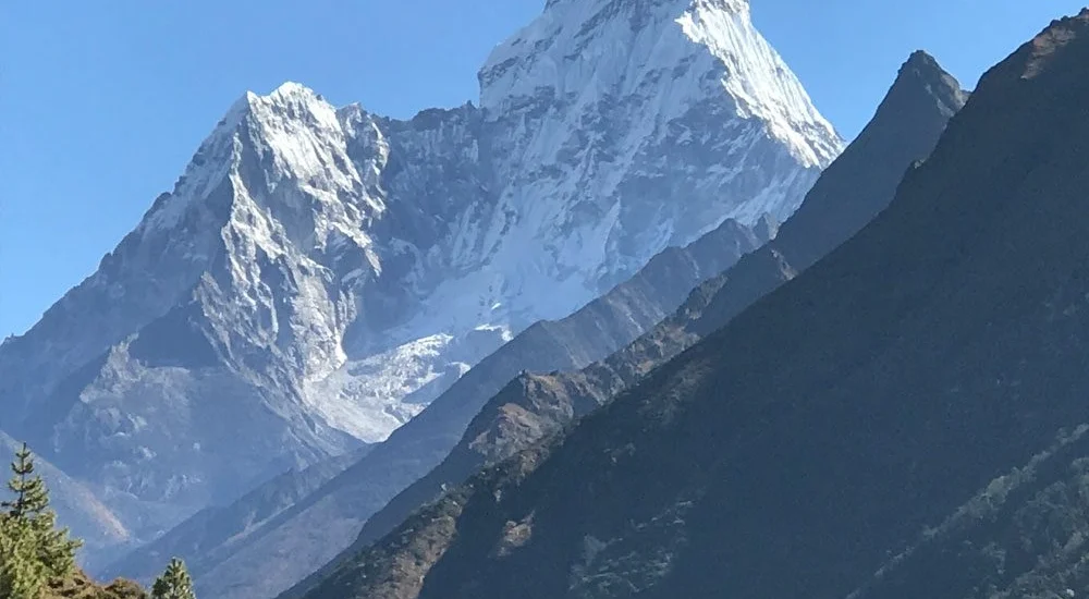
Few mountains draw climbers’ eyes quite like Ama Dablam. Its dramatic, pyramid-like profile and genuine technical demands make it a bucket-list objective for mountaineers at every stage of their climbing journey.
Standing 6,812 meters (22,349 feet) tall, Ama Dablam dominates the skyline of Nepal’s Khumbu region and can be spotted from Everest Base Camp itself. Local Sherpas call it the “Mother’s Necklace,” a nod to the hanging glacier that drapes from its summit ridge like a piece of jewelry.
The peak sits within Sagarmatha National Park, making it a striking backdrop for anyone trekking through the Everest region trails.
Sir Edmund Hillary led the team that first summited the mountain on March 13, 1961, climbing the Southwest Ridge — still the go-to route for expeditions today.
Because of its rock, ice, and fixed-rope terrain, Ama Dablam calls for genuine alpine skills: comfort with crampons, ice axes, jumaring, and steep ridgeline movement. This is not a beginner-friendly trekking peak — prior mountaineering background is essential before attempting it.
A full expedition typically runs 28 to 30 days, covering the trek in to base camp, acclimatization periods, the establishment of higher camps, and the eventual summit attempt.
Autumn is generally regarded as the prime climbing window, offering clearer skies, lighter precipitation, and milder temperatures. Spring is a solid second choice, though it can bring less predictable weather, afternoon cloud buildup, and occasional snow.
Reaching the 6,812-meter summit is only part of the appeal. An Ama Dablam expedition means stepping onto one of the Himalayas’ most visually striking and technically respected peaks, deep in Nepal’s Khumbu region.
The Southwest Ridge throws steep rock, ice sections, and narrow ridge traverses at climbers, calling for solid skill with crampons, ice axes, ropes, and rock moves rated up to 5.7 — a notch well above what’s needed on Nepal’s standard trekking peaks.
Thanks to its sharp, pyramidal silhouette, Ama Dablam has earned the nickname “Matterhorn of the Himalayas” and ranks among the most photographed peaks on Earth. It looms over the Everest Base Camp trail, delivering unforgettable views to trekkers passing below.
For climbers eyeing an eventual attempt on an 8,000-meter giant, Ama Dablam serves as ideal preparation. It builds the acclimatization base and technical confidence needed before tackling Everest, Manaslu, or similar high-altitude objectives.
Climbers face thrilling exposure along narrow ridgelines with drops stretching roughly a thousand meters. From the top, the reward is a sweeping panorama of Everest, Lhotse, Nuptse, Makalu, and the wider Khumbu skyline.
Standing on Ama Dablam’s summit carries real weight in the climbing community. It’s a technical achievement that goes beyond what most high-altitude trekkers ever attempt, setting successful climbers apart.
With solid preparation and a professional support team, Ama Dablam is a manageable objective for seasoned mountaineers. The standard Southwest Ridge route benefits from pre-installed fixed ropes, seasoned Sherpa guides, on-site medical care at Base Camp, emergency oxygen supplies, weather forecasting, and helicopter evacuation options up to roughly 6,500 m when conditions allow.
Sitting well below the 8,000-meter peaks also means climbers face fewer of the extreme risks tied to very high altitude.
That said, this remains a serious Himalayan undertaking. Rockfall, icefall, ridgelines with severe drop-offs, shifting weather, and altitude-related illness above 6,000 m are all real concerns. Overall, it’s considered less risky than an 8,000-meter expedition, yet noticeably more demanding than a trekking peak like Island Peak.
The expedition follows the Southwest Ridge — the same historic line used during the 1961 first ascent and still the most trusted path up the mountain. It delivers consistent technical climbing paired with breathtaking exposure throughout.
| Day | Route | Elevation |
| Day 1 | Arrival in Kathmandu | 1,350 m / 4,429 ft |
| Day 2 | Rest day in Kathmandu — expedition briefing, permit processing, sightseeing, and gear prep | 1,350 m / 4,429 ft |
| Day 3 | Flight from Kathmandu to Lukla; trek onward to Phakding | 2,651 m / 8,698 ft |
| Day 4 | Trek from Phakding to Namche Bazaar | 3,440 m / 11,286 ft |
| Day 5 | Acclimatization day in Namche Bazaar | 3,440 m / 11,286 ft |
| Day 6 | Trek from Namche to Pangboche | 3,985 m / 13,074 ft |
| Day 7 | Trek from Pangboche to Ama Dablam Base Camp | 4,600 m / 15,092 ft |
| Day 8 | Base Camp setup and acclimatization day | 4,600 m / 15,092 ft |
| Days 9–20 | Skills training and rotation climbs: Base Camp → Camp 1 → Camp 2 → Base Camp | 4,600 m |
| Days 21–25 | Summit push: Base Camp → Camp 2 → Summit, then descent to Camp 2 or Base Camp | 6,812 m / 22,349 ft |
| Day 26 | Trek back from Base Camp to Namche Bazaar | 3,440 m / 11,286 ft |
| Day 27 | Trek from Namche Bazaar to Lukla | 2,850 m / 9,350 ft |
| Day 28 | Flight from Lukla to Kathmandu; hotel transfer | 1,350 m / 4,429 ft |
| Day 29 | Farewell dinner and certificate presentation | 1,350 m / 4,429 ft |
| Day 30 | Final departure | 1,350 m / 4,429 ft |
Note: Experienced climbers working with a tighter schedule can request a customized, shortened itinerary.
Budgeting for an Ama Dablam climb typically falls somewhere between USD $7,500 and $12,000, with the final figure shaped by the type of service package chosen. Group-based budget trips start around $7,500 and cover the essentials, while premium expeditions featuring seasoned Sherpa guides and upgraded facilities can run $12,000 or higher.
| Category | Cost (USD) | What’s Included |
| Climbing Permit | $400–$600 per trekker | Official Nepal government climbing permit, arranged through a licensed expedition operator; price varies by climbing season |
| Liaison Officer Charge | $2,500–$3,000 per team (split among members) | A government-required fee that covers the officer’s wages, gear, insurance, and logistical support |
| Base Camp Services | $2,000–$3,500 per person | Includes base camp tent setup, dining tent, kitchen crew, meals, and communication equipment |
| Climbing Sherpa Support | $3,000–$5,000 | A skilled climbing Sherpa handling route fixing, high-altitude assistance, safety backup, and summit-day support |
| Supplemental Oxygen (Optional) | $400–$600 | Backup oxygen supply for emergency use |
| Personal Climbing Gear | $1,500–$3,000 | Technical equipment, high-altitude clothing, mountaineering boots, harnesses, and related gear |
| Travel & Rescue Insurance | $200–$500 | Mandatory coverage for travel and helicopter evacuation, valid up to 7,000 m |
| Total Expedition Cost | $7,500–$12,000 | Final price depends on the service tier, operator, and level of support selected |
Want a fully itemized quote tailored to your trip? Reach out to our expedition specialists for personalized guidance.
Day 1: Land in Kathmandu
Day 2: Kathmandu rest day — briefing, permit processing, city sightseeing, and final trip prep
Day 3: Flight to Lukla, followed by the trek to Phakding
Day 4: Trek from Phakding onward to Namche Bazaar
Day 5: Acclimatization day in Namche Bazaar
Day 6: Trek from Namche Bazaar to Pangboche
Day 7: Trek from Pangboche to Ama Dablam Base Camp
Day 8: Base Camp setup and acclimatization
Days 9–20: Rotation training between Base Camp, Camp 1, and Camp 2 (4,600 m)
Days 21–25: Summit push — Base Camp to Camp 2 to the 6,812 m summit, then descent to Camp 2 or Base Camp
Day 26: Trek from Base Camp back to Namche Bazaar
Day 27: Descend from Namche Bazaar (3,440 m / 11,286 ft) to Lukla
Day 28: Fly from Lukla to Kathmandu and check into the hotel
Day 30: Final departure from Nepal
Autumn stands out as the top season for an Ama Dablam attempt, thanks to more reliable weather, safer climbing conditions, and historically strong summit success rates. Here’s a closer season-by-season look:
Autumn (October–November) This is the most popular and reliable window for climbing Ama Dablam, bringing stable weather, clear skies, and low precipitation — all contributing to the highest summit success rates of the year.
Wind speeds generally sit in the 20–40 km/h range — gusty but manageable, even at higher camps. Summit windows tend to be longer and more frequent, typically offering 3 to 7 consecutive favorable days for a push to the top.
At Camp II (6,000 m), nighttime temperatures range from -10°C to -20°C, while daytime readings hover between -5°C and +5°C on sunny days.
Spring (April–May) Spring expeditions are less common and come with more unpredictable conditions. As the monsoon approaches, winds grow stronger and less consistent. Summit windows shrink to just 1–3 days, with weather shifting rapidly. While nighttime temperatures at Camp II are somewhat milder (-5°C to -15°C), afternoon cloud buildup, precipitation, and avalanche risk make spring a technically trickier and riskier season for climbers.
Ama Dablam is not a peak for first-time climbers — solid mountaineering experience is essential beforehand. Climbers should have already summited at least one 6,000-meter peak, such as Island Peak, Mera Peak, or Lobuche East, to prove they can perform well at high altitude.
Strong skills with an ice axe and crampons are non-negotiable given the steep 50–70° ice slopes encountered on route, requiring confidence in front-pointing, self-arrest technique, and efficient movement on steep ice.
Solid cardiovascular fitness is equally important for sustaining 6–8 hour climbing days at altitude while carrying moderate loads. Useful training includes long-distance running, stairmaster sessions, high-intensity interval workouts, and multi-day backcountry treks.
Ama Dablam expeditions follow strict safety procedures for high-altitude emergencies. Rescue operations above 6,000 meters are inherently difficult and heavily weather-dependent, coordinated with Kathmandu-based rescue teams — meaning climbers need to be largely self-reliant in the event of trouble.
Helicopter rescue is possible up to about 6,500 meters, conditions and air density permitting. Travel insurance is required for all climbers, with a minimum coverage of USD $100,000; evacuation costs typically range from $5,000 to $15,000.
Base Camp maintains a stocked medical kit covering altitude medications like Diamox and dexamethasone, antibiotics, wound care supplies, oxygen equipment, and pulse oximeters. Expedition leaders carry wilderness first-aid training.
Daily weather forecasts — covering wind, precipitation, temperature, and summit-window conditions — come from professional forecasting services to guide key climbing decisions.
Backup oxygen bottles are kept on hand at high-altitude camps for emergencies, though supplemental oxygen isn’t required for a standard Ama Dablam climb.
Seasoned Sherpa Expedition Leadership — Our climbs are guided by certified IFMGA/UIAGM mountain guides with multiple Ama Dablam summits and over two decades of Himalayan climbing experience behind them, bringing sound judgment and expert decision-making to every stage of your climb.
A Deep, Capable Team — Our climbing Sherpas each bring 5 to 10+ Ama Dablam summits to the table, and we maintain a 1:2 Sherpa-to-climber ratio on summit day for close, reliable support.
A Track Record That Speaks for Itself — Over the past six years, we’ve maintained an 80–90% summit success rate, well ahead of the industry standard.
Built-In Emergency Backup — Our safety net includes satellite communication, round-the-clock Base Camp support, pre-arranged helicopter rescue contracts, backup oxygen at high camps, and trained medical staff on hand.
Straightforward, Transparent Pricing — No hidden fees. Every cost — permits, Base Camp services, Sherpa support, group gear, meals, tented accommodation, and emergency backup — is laid out clearly upfront.
Landing at Tribhuvan International Airport, you’ll be greeted by a member of our team offering a traditional khata scarf before being driven to your Thamel hotel — a ride that usually takes 20–30 minutes depending on traffic. Kathmandu Valley sits ringed by green hillsides, and the drive gives you a first taste of Nepal’s urban character: bustling lanes, colorful houses, and pagoda rooftops rising over the skyline.
Once you’ve checked in and settled, you’re free to rest after the flight or wander through Thamel’s maze of trekking outfitters, cafes, and cultural landmarks. That evening brings a welcome dinner of authentic Nepali dishes and a chance to connect with fellow expedition members before the trail begins.
Reminder: keep your travel documents and insurance paperwork ready for the next day’s briefing.
The second day is dedicated to expedition logistics. Your expedition leader walks the group through the climbing plan, acclimatization strategy, safety protocols, and emergency procedures. Permit paperwork — including the Ama Dablam climbing permit — gets finalized, and a full gear check ensures boots, crampons, harnesses, and high-altitude equipment are climb-ready.
If time allows, the afternoon includes a short cultural stop at Swayambhunath or Boudhanath Stupa, offering a glimpse of Kathmandu Valley’s Hindu and Buddhist heritage before heading into the mountains.
The adventure kicks off with an early flight to Lukla, home to one of the most dramatic mountain airstrips on the planet. The short hop delivers stunning aerial views of the Himalayan range, and on clear mornings, distant glimpses of Everest, Lhotse, and Ama Dablam itself.
From Lukla, the trekking trail begins — winding through forested paths, Sherpa settlements, prayer flag lines, mani walls, and swinging suspension bridges. The walk to Phakding is gentle and largely downhill, making it a comfortable warm-up for the trek ahead. Phakding itself is a peaceful riverside village with cozy teahouses, marking the gateway into the Khumbu region.
Trekking tip: During the busy autumn and spring seasons, Lukla flights often depart from Ramechhap Airport instead of Kathmandu due to air-traffic regulations, so plan an early start for the road transfer to Ramechhap.
The trail follows the Dudh Koshi River valley through blue pine forest, crossing several suspension bridges including the well-known Hillary Bridge near Monjo. The Monjo checkpoint marks the entrance to Sagarmatha National Park, home to Himalayan tahr, musk deer, and the occasional red panda sighting. Near the river confluence at 2,835 m, the Dudh Koshi meets the Bhote Koshi.
The day’s final push is a demanding 2–3 hour climb, gaining around 600 meters via switchback trails. Partway up, a viewpoint delivers the trek’s first big mountain reveal — Everest (8,848 m), Lhotse (8,516 m), and Ama Dablam (6,812 m) rising above the ridgelines.
Namche Bazaar (3,440 m), the unofficial Sherpa capital, appears as a bowl-shaped town built into the hillside. This lively trading hub offers bakeries, gear shops, internet cafes, a Saturday market, and the Sagarmatha National Park Museum. As the sun sets, Kongde Ri (6,187 m) and Thamserku (6,623 m) glow alongside a golden-lit Ama Dablam.
This rest day follows the classic mountaineering rule of “climb high, sleep low,” using light activity to help the body adapt and boost red blood cell production.
After breakfast, a two-hour hike leads to the Everest View Hotel (3,880 m), the highest-altitude hotel in the world, passing through Syangboche village (3,720 m) and its helicopter pad, along with patches of rhododendron and juniper forest. The hotel’s terrace offers a full 180-degree panorama of Everest, Lhotse, Ama Dablam, Thamserku, Kongde, and Khumbila — arguably the best viewpoint in the whole Khumbu region.
Alternative options: Khumjung village (3,780 m), home to the Edmund Hillary School and a monastery said to house a Yeti scalp relic, or Kunde village (3,840 m), where the Hillary Hospital is located.
In the evening, options include browsing the Saturday Tibetan market (schedule permitting), visiting the Sherpa Culture Museum to learn about mountaineering history, or stopping by the Sagarmatha National Park Museum. Overnight stay in Namche Bazaar.
The trail continues along the valley’s eastern flank with views of Everest, Nuptse, and Lhotse. Passing through Kyangjuma (3,550 m) and Sanasa (3,600 m), the route crosses open alpine meadows dotted with grazing yaks.
Around 3,700 m, the trail climbs through forests of rhododendron, birch, and juniper toward Tengboche Monastery (3,860 m) — the most significant Buddhist monastery in the Khumbu, dramatically framed by Ama Dablam. Home to around 60 monks, colorful murals, and Buddha statues, it’s sometimes possible to catch the 3 PM prayer ceremony.
The trail then drops steeply through rhododendron forest, crosses the Imja Khola bridge (3,710 m), and climbs again through Deboche (3,820 m) and Milingo (3,870 m) before reaching Pangboche (3,985 m) — the highest year-round settlement in the area, home to the centuries-old Pangboche Gompa, the Khumbu’s oldest monastery. Evening brings close-up views of Ama Dablam’s south face glowing in alpenglow over its hanging glacier.
After breakfast, the trail branches off from the main Everest route toward Ama Dablam Base Camp. The path crosses sparse alpine terrain of juniper scrub and rocky moraine, past glacial streams, prayer flags, and memorial chortens. Views open up toward Kantega (6,782 m), Thamserku (6,623 m), and the Lhotse-Nuptse wall, with a chance of spotting Himalayan griffon vultures overhead.
Crossing lateral moraine ridges leads to Base Camp (4,600 m), set beside the Mingbo La Glacier directly beneath Ama Dablam’s towering 2,200-meter southwest face. Camp facilities include a dining tent, kitchen tent, communications tent, toilets, and solar-lit sleeping tents. The afternoon covers camp orientation, introductions with the climbing Sherpa team, an acclimatization overview, and a briefing on the route toward Camp I (5,700 m). Overnight temperatures typically drop to between -10°C and -15°C.
A rest-and-readiness day focused on altitude adjustment. Mornings are spent organizing gear and inspecting safety equipment — carabiners, harnesses, helmets, crampons, headlamps, and ascenders — followed by technical skills practice: jumaring on fixed ropes, changeovers at rope anchors, clipping technique, rappelling with a safety backup, and radio communication protocols.
A short acclimatization walk, gaining 100–200 m above camp, offers views of steep rock buttresses and hanging glaciers along the route. The afternoon includes a detailed briefing on climbing rotations, load-carrying strategy, timing, summit planning, weather monitoring, and emergency evacuation procedures.
The day closes with a traditional Buddhist puja ceremony, where a lama chants prayers, burns juniper incense, and makes offerings of rice and tsampa to the mountain deities while prayer flags are strung above camp. All climbers take part and receive blessed rice and silk scarves to carry on the climb. In the evening, summit bags are packed with down suits, insulated boots, gloves, goggles, face protection, high-energy snacks, insulated bottles, and emergency supplies.
Climbers cross boulder fields and moraine to reach fixed ropes at around 4,900 m, navigating steep rock slabs and mixed terrain using jumar ascenders. Rope pitches run 50–60 meters, with sections angled between 45 and 55 degrees. Near 5,400 m, a hanging glacier brings crevasse hazards and serious exposure. Camp I sits on a narrow ridge with sweeping 360-degree views of Everest, Lhotse, and the wider Khumbu — some groups descend to Base Camp the same day, while others overnight at Camp I.
Rest Days: One to two days back at Base Camp allow the body to recover — replenishing red blood cells, regulating breathing, and repairing tissue — through light walks, gear checks, and steady hydration (4–5 liters daily) alongside carb-rich meals.
Days 13–15 — Second Rotation to Camp II (6,000 m): From Base Camp to Camp I (with a possible overnight), then onward the next day past the wind-carved ice formations known as “Mushroom Ridge.” This stretch mixes rock and ice climbing at 50–65 degrees, including rock sections rated 5.5–5.7. The notorious “Rock Band” at 5,900 m — Ama Dablam’s technical crux — demands careful crampon work on steep rock. Camp II perches on an extremely exposed, narrow ridge with thousand-meter drops on both sides and frequent strong winds. Climbers typically spend one night before descending back to Base Camp.
Days 16–18: Recovery, weather monitoring, and gear preparation.
Days 19–20: Final readiness — packing summit equipment, reviewing safety protocols, coordinating with the Sherpa team, and watching the forecast for a suitable weather window.
Day 21 — Base Camp to Camp I (5,700 m): Climb time 6–8 hours, gaining roughly 1,100 m. An early wake-up (6–7 AM) sets the team on the now-familiar route, reaching camp by early afternoon for rest and rehydration. A late-night wake-up follows to organize summit gear, test headlamps, and fill bottles with hot tea and soup — sleep is difficult at this altitude with the wind picking up.
Day 22 — Camp I to Camp II (6,000 m): Climb time 5–6 hours, gaining about 300 m. Waking around 7–8 AM, climbers tackle technical, exposed ridge and rock-band sections. That night, summit clothing is laid out, snacks packed, and bottles filled — adrenaline and thin air make rest around 6–7 PM nearly impossible.
Day 23 — Summit Day: Camp II to the 6,812 m Summit: A 10–14 hour round trip gaining 812 m. - 11 PM–12 AM: Wake for tea and a light meal; gear up fully for the summit push. - 12–1 AM: Depart camp for a steep mixed climb on fixed ropes, front-pointing crampons, and jumar ascending in low visibility. - 2–4 AM: Navigate past the near-vertical Yellow Tower and Grey Tower rock outcrops, with careful anchor-to-anchor transitions in temperatures below -20°C. - 4–6 AM: Pre-dawn light reveals the surrounding peaks as climbers cross the knife-edge summit ridge, with severe drop-offs on both sides demanding total focus. - 6–8 AM: The final summit pyramid, angled at 60–65 degrees, tests endurance as the thin air — roughly half the oxygen available at sea level — makes every step laborious. - 8–9 AM: Reaching the 6,812 m / 22,349 ft summit rewards climbers with a full panorama of Everest (8,848 m), Lhotse (8,516 m), Nuptse (7,861 m), Makalu (8,463 m), Cho Oyu (8,188 m), and countless 6,000–7,000 m peaks. Summit time is kept brief — 15 to 30 minutes. - 9 AM–2 PM: The descent to Camp II requires careful rappelling despite fatigue, with avalanche risk and dehydration as key concerns. Climbers typically arrive at Camp II by midday to rest.
Days 24–25 — Descent to Base Camp: The descent takes one to two days, requiring sustained focus through rappels and exposed terrain. Arrival at Base Camp brings a wave of relief, celebration, and noticeably thicker air at 4,600 m.
The return trek retraces the route through Pangboche and Tengboche back down the valley to Namche Bazaar. Trekking poles help ease the strain on tired knees. A hot shower, cold drink, and celebratory stop at a bakery or restaurant await, followed by deep, well-earned sleep in oxygen-richer air.
The trail descends through lush vegetation, passing Phakding and following the Dudh Koshi River through pine woodland back to Lukla. The evening brings a celebration dinner with the guide and Sherpa team — swapping stories, sharing photos, and expressing thanks, along with tipping the support crew. It’s worth confirming the next day’s flight schedule with your guide.
An early morning flight offers one last look at the mountains before landing back in Kathmandu and transferring to the hotel. The rest of the day allows for a hot shower, a comfortable bed, and time to relax, shop, or enjoy a massage. The evening closes with a farewell dinner and certificate presentation. (This day also serves as a buffer in case of Lukla flight delays.)
Extra time in Kathmandu for sightseeing, shopping, spa visits, or simply resting and reflecting on the climb — a good chance to review photos and journal the experience.
Airport transfer takes place about three hours before your flight, closing out the trip with a traditional khata farewell. Most climbers recommend allowing 2–3 weeks of rest and recovery after returning home.
Where you sleep and eat shifts as you gain elevation throughout the expedition. In Kathmandu, comfortable 3–4 star hotels offer modern amenities, hot showers, breakfast, and Wi-Fi, typically running USD $50–$100 a night. Along the trekking trail toward Base Camp, teahouses provide simple twin-share rooms with shared dining halls serving trekking staples like dal bhat, noodles, soup, and Tibetan bread.
At Base Camp: Climbers stay in a tented camp setup with separate dining, sleeping, kitchen, and toilet tents. A dedicated expedition cook prepares calorie-dense, nutritious meals — think pasta, rice, soups, vegetables, meat dishes, and hot drinks — to fuel the climb ahead.
At the High Camps: Camp I (5,700 m), Camp II (6,000 m), and Camp III (6,300 m) rely on lightweight alpine tents, with meals scaled down to freeze-dried options, instant noodles, energy bars, and hot drinks, reflecting the limited facilities and harsh conditions at these altitudes.
Climbing Ama Dablam requires three separate permits. The Nepal Department of Tourism climbing permit costs $400 per person in spring, $600 in autumn, $200 in winter, and $125 in summer. Entry into Sagarmatha National Park — a UNESCO World Heritage Site — requires a permit costing NPR 3,000 (roughly $23) for foreign trekkers. A local permit from the Khumbu Pasang Lhamu Rural Municipality costs NPR 2,000 (about $15) and goes toward supporting local infrastructure and waste management. All three permits must be processed through a registered Nepal-based expedition operator.
Namche Bazaar to Pangboche (3,440–3,985 m): Villages along this stretch get patchy 3G/4G coverage from Ncell and Nepal Telecom, though the signal thins out the higher you climb above Namche. Pangboche has only a weak connection.
Base Camp (4,600 m): No reliable mobile network here — Ncell occasionally reaches parts of the camp, but connectivity shouldn’t be counted on.
High Camps (Camp I – 5,700 m, Camp II – 6,000 m, Summit – 6,812 m): No mobile coverage at all. Communication between camps and Base Camp relies on satellite phones and two-way radios.
Gearing up for Ama Dablam is nothing like packing for a standard trekking peak — this is a serious technical climb to 6,812 meters, and every item in your bag needs to earn its place.
Weight matters, but reliability matters more. Once you leave Base Camp behind, there’s no swapping out faulty gear — everything has to hold up against high winds, subzero cold, and serious exposure along knife-edge terrain like the Southwest Ridge.
Here’s a professional-grade packing checklist built for safety and performance at altitude.
Head & Eye Protection - Primary headlamp (300+ lumens) - Backup headlamp - Spare batteries (extra sets) - Ski goggles
Footwear - Double plastic mountaineering boots (rated to -40°C) - Trekking boots or approach shoes - Mountaineering socks (4–5 pairs) - High mountaineering gaiters
Clothing Layers - Thermal tops (2) - Thermal bottoms (2) - Fleece jacket - Softshell jacket - Insulated synthetic jacket - Down jacket (rated -20°C to -30°C) - Down pants - Hardshell waterproof jacket and pants
Personal Care Items - Sunscreen - Lip balm - Hand sanitizer - Toilet paper - Toothpaste - Quick-dry towel
Technical Climbing Gear - 12-point crampons - Ice axe (60–70 cm) - Mountaineering harness - Climbing helmet - Locking carabiners - Non-locking carabiners - Jumar ascenders - Belay/rappel device - Prusik cords (2) and slings
Other Essentials - Sleeping bag (rated -30°C to -40°C) - Summit pack (30–40 L) - Insulated sleeping pad (R-value 5+) - Water bottles and thermos - Energy bars and energy gels - Personal first-aid kit - Camera with spare batteries - Power banks - Travel insurance documents and passport
Ama Dablam is a genuinely technical mountaineering objective, combining rock, ice, and exposed fixed-rope terrain along the Southwest Ridge Route. It sits well above trekking peaks like Island Peak in difficulty and isn’t a suitable choice for first-time climbers.
Yes — most expedition operators require climbers to have already summited a 6,000-meter peak such as Island Peak or Mera Peak, along with a solid level of physical fitness. This is not a climb suited to beginners.
Autumn, spanning October through November, is widely considered the ideal window thanks to clear skies and a lower risk of avalanches.
Expect roughly 28 to 32 days total, covering acclimatization, the summit push, and the return trek back to Kathmandu.
Costs generally fall between $7,500 and $12,000, depending on the service package and level of support chosen.
Technically, yes — Ama Dablam demands more advanced climbing skill. Everest, on the other hand, poses a greater physical challenge due to its extreme altitude. For this reason, many climbers use Ama Dablam as training and preparation before attempting Everest.
No — Ama Dablam is typically climbed without supplemental oxygen, though some climbers carry emergency oxygen as a safety backup.
Like most Himalayan expeditions, Ama Dablam carries typical mountain risks — rockfall, avalanche potential, altitude sickness, and unpredictable weather. With experienced Sherpa support and a well-paced acclimatization schedule, these risks are managed effectively.
Climbers follow the Southwest Ridge Route, passing through Camp I (5,700 m) and Camp II (6,000 m) before tackling technical rock and ice terrain and the exposed summit ridge — widely regarded as one of the most stunning climbing lines in the Himalayas.
The journey starts in Kathmandu, followed by a flight to Lukla, a multi-day trek through the Khumbu region, and the final approach to Ama Dablam Base Camp.
With 10+ years of expertise in Nepal, Tibet, and Bhutan, Binaya is the right person to help you create a trip you’ll never forget.